Directions to St. Augustine
We're right on the Atlantic coast just an hour south of Jacksonville. St. Augustine is surprisingly convenient to other popular Florida cities such as Orlando and Cape Canaveral. For Florida residents, it quickly becomes the yearly family vacation destination of choice since the ride over isn't too arduous and the city has something new to offer every time. From history to beach lounging: make St. Augustine your tradition.
Use this interactive Google Map for directions from your location to your destination in St. Augustine, or view our general directions below.
If you're driving...
Directions from I-95 into the St. Augustine Historic District
Take Exit 318 onto State Road 16 headed east (you'll make a left turn when you come off the exit ramp). Follow SR16 approximately five miles until you cross the railroad tracks and arrive at the traffic light of US1. Make a right turn onto US1 South. Approximately one mile down the road (at the second traffic light) make a left onto West Castillo Drive. This street will dead end at San Marco Blvd., turn right to drive into the St. Augustine bayfront area or park at the Visitor's Center parking garage on the corner of Castillo Drive and San Marco.
If you're flying...
Directions to St. Augustine from the Jacksonville Airport (Approximately 52 miles)
Begin at Jacksonville International Airport terminal and go East for about 0.5 mile. Continue on Airport access road to I-95. Bear right onto I-95 ramp and go South for about 50 miles. Exit on to SR 16 (exit 318)and turn left (East) and follow it to US1. Turn right onto US1 and follow it to W. Castillo Dr. (2nd traffic light). Turn left onto W. Castillo Dr. to the Municipal parking lot and the Visitors information Center.
Directions to St. Augustine from the Orlando Airport (Approximately 118 miles)
Begin at Orlando International on Airport Exit and go South for 500 feet. Turn hard left on South Access Rd and go North for 300 feet. Continue on Airport Blvd E at sign reading "Terminal A" and go North for 1.6 miles. Bear left on SR-436, S Semoran Blvd and go North for 6 miles. Turn right on ramp at sign reading "SR-408-Toll W to Downtown / Orlando" and go Southeast for 900 feet. Bear right on East-West Expy, Holland East-West Expy, SR-408 and go West for 4.3 miles. Exit East-West Expy, Holland East-West Expy, SR-408 via ramp at sign reading "Exit 10A I-4 to Tampa / Daytona Beach" and go Southwest for 1.2 miles. Bear right on I-4, SR-400 and go Northeast for 50 miles. Exit I-4, SR-400 via ramp at sign reading "I-95 N to Jacksonville" and go North for 0.8 miles. Bear right on I-95, SR-9 and go North for 37 miles. Exit I-95, SR-9 via ramp at sign reading "Exit 92 US-1 to St Augustine" and go Northwest for 0.3. Bear right on US-1 S, SR-5 and go North for 17 miles. Turn right on W Castillo Dr and go East for 0.2 miles. Turn right on Cordova St and go to the Municipal parking lot and the Visitors information Center.
Directions to St. Augustine from the Miami Airport (Approximately 317 miles)
Begin at Miami International on Departures-Upper Level and go East for 0.3 miles. Continue on Airport Exit and go East for 0.2 miles. Continue on NW 21st St and go East for 1000 feet. Continue on ramp and go Northeast for 0.5 miles. Continue on Airport Expy,SR-112 and go East for 3.9 miles. Continue on ramp at sign reading "I-95 N / I-95 S to Ft Lauderdale / Orlando / Downtown" and go Northeast for 0.9. Continue on I-95 and go North for 294 miles. Exit I-95 via ramp at sign reading "Exit 92 US-1 to St Augustine" and go Northwest for 0.3 miles. Bear right on US-1 S, SR-5 and go North for 17 miles. Turn right on W Castillo Dr and go East for 0.2 miles. Turn right on Cordova St and go to the Municipal parking lot and the Visitors information Center.
Area Parking
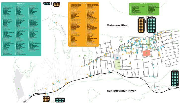
Our following map shows handicap accessible parking around the downtown area in relation to Things to Do and Accommodations


